Whether you’re designing a new home, adding an extension, or lodging a Development Application (DA), a detail survey is typically required by architects and designers for design purposes, and some councils and certifiers.
Many councils and certifiers however, now require your property’s boundaries to be calculated and defined – contour surveys only place your property boundaries in an approximate location. For this level of detail, you will likely require a Detail & Level Identification Survey. For more information, you can contact our team on (02) 9167 0209 and by clicking the link here.
- What Does a Detail Survey Include?
- Why is a Detail Survey Required?
- Benefits of a Detail Survey
- What’s the Process?
- 3D Detail Survey Option
- Choosing the Right Surveyor
- Get Started with C&A Surveyors
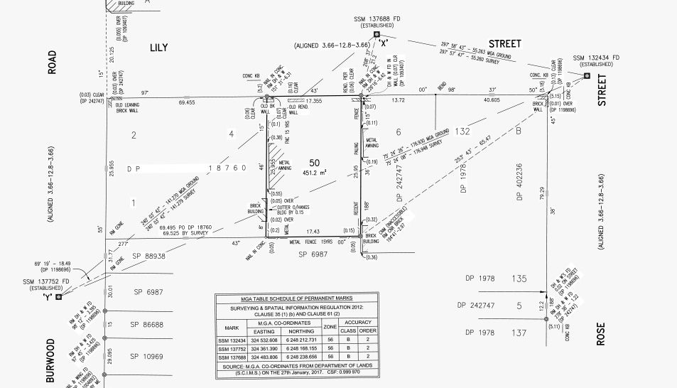
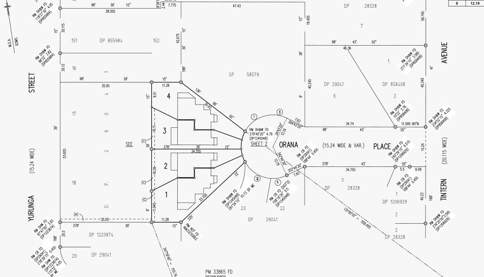
What Does a Detail Survey Include?
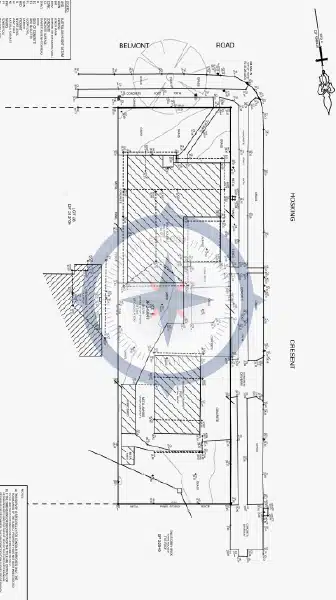
Detail surveys capture both horizontal and vertical information about your land. This includes:
- Contours
- Site coordination
- Location of features
- Ridge and gutter heights
- Outline of neighbouring buildings
- Levelling
- Spot levels
This information is compiled into a scaled plan — either 2D or 3D — used by your design professionals and required by council for approval processes.
Why is a Detail Survey Required?
1. Planning and Building Applications
Some local councils in NSW require a detail survey to accompany Development Applications (DA) or Complying Development Certificate (CDC) submissions. It ensures:
- Accurate design in line with site conditions
- Safe, compliant construction
- Neighbouring impact assessments (such as overshadowing and setbacks)
As mentioned earlier, many councils and certifiers now require your property’s boundaries to be calculated and defined – contour surveys only place your property boundaries in an approximate location. For this level of detail, a Detail & Level Identification Survey may be more appropriate.
2. Architectural and Engineering Design
Architects use detail surveys to create site-responsive designs. Without accurate land levels and structure locations, designs may need costly changes later. Engineers also rely on them for stormwater planning, earthworks, and structural design.
3. Property Valuations and Sales
Banks, valuers, and potential buyers may request a detail survey to better understand the land’s characteristics and development potential.
4. Site Analysis and Feasibility Studies
Before investing time and money into design work, a detail survey helps identify potential constraints — such as drainage flows or sloping land.
Benefits of a Detail Survey
- Design with precision: Avoid costly redesigns by planning with accurate information
- Streamline approvals: Council and certifier-ready plans reduce delays in DA or CDC submissions
- Prevent site surprises: Identify challenges early such as sloping land
- Enhance communication: Clear survey plans help architects, builders, engineers, and certifiers stay aligned
What’s the Process?
At C&A Surveyors, we aim to make the process simple and hassle-free:
- Initial Brief – We work with you or your designer to understand your project’s requirements.
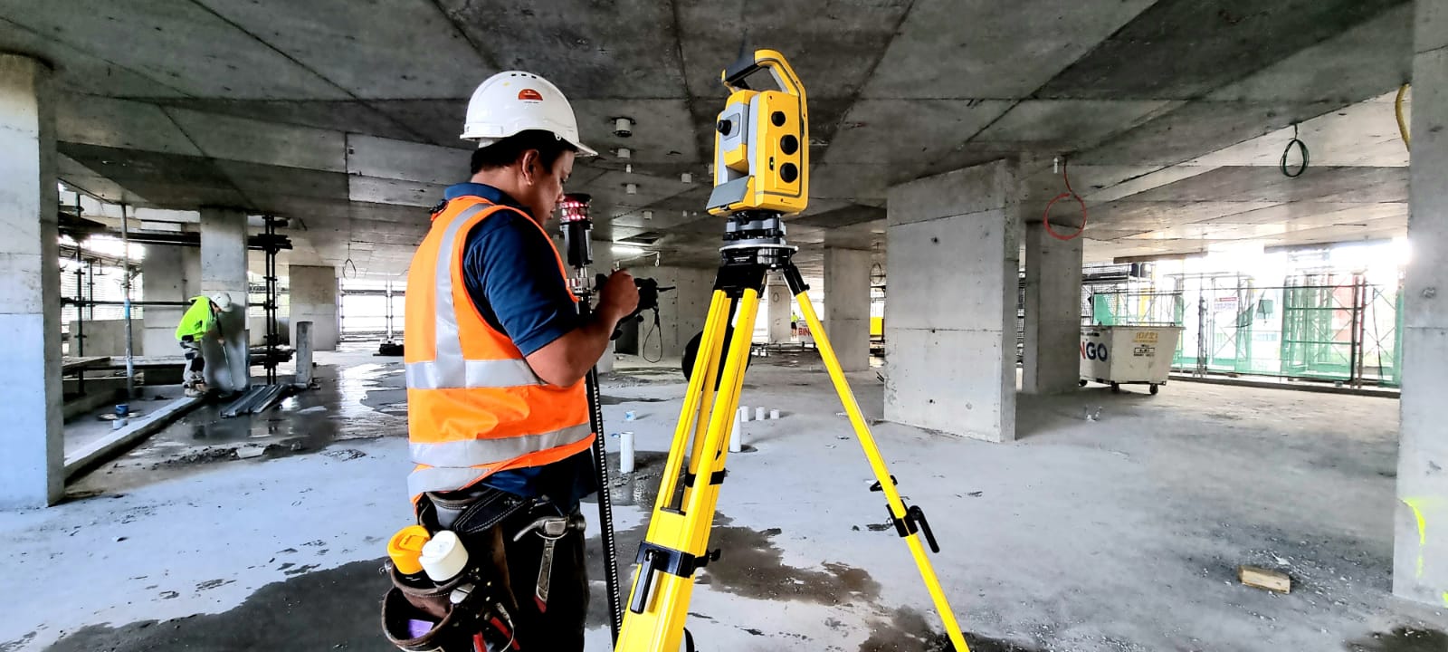
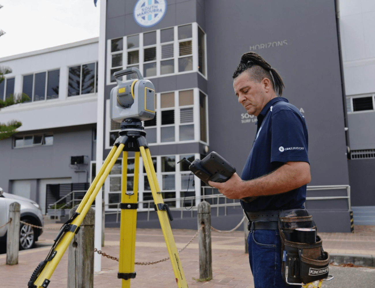
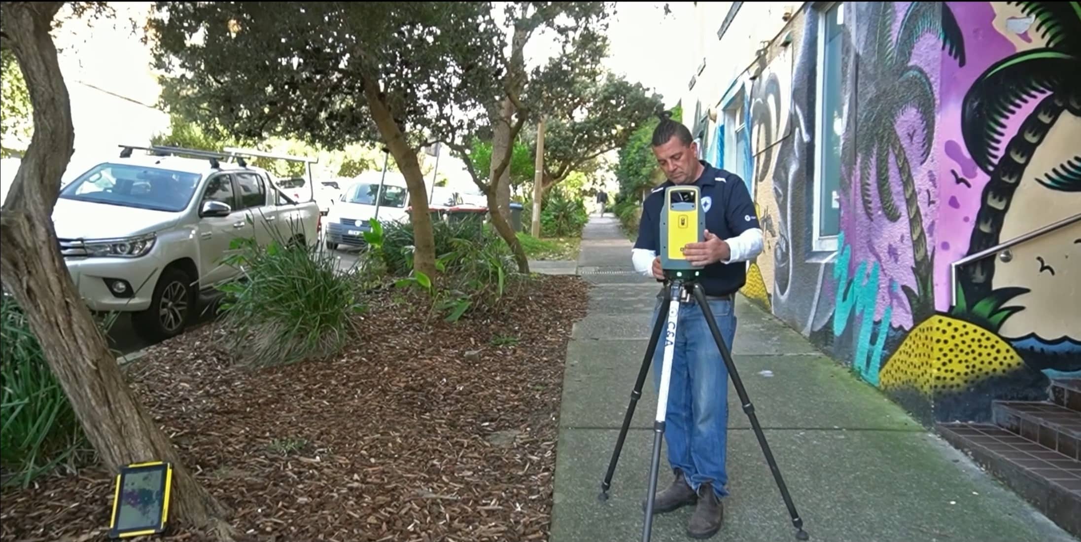
- On-Site Survey – Our registered surveyors attend the property to capture all required data.
- Plan Preparation – We draft the information into a professional survey plan tailored to your application or design needs.
- Delivery – Plans are delivered in PDF and CAD formats, ready to hand over to your architect, builder, or council.
You can see how we bring our surveys to life in our video below:
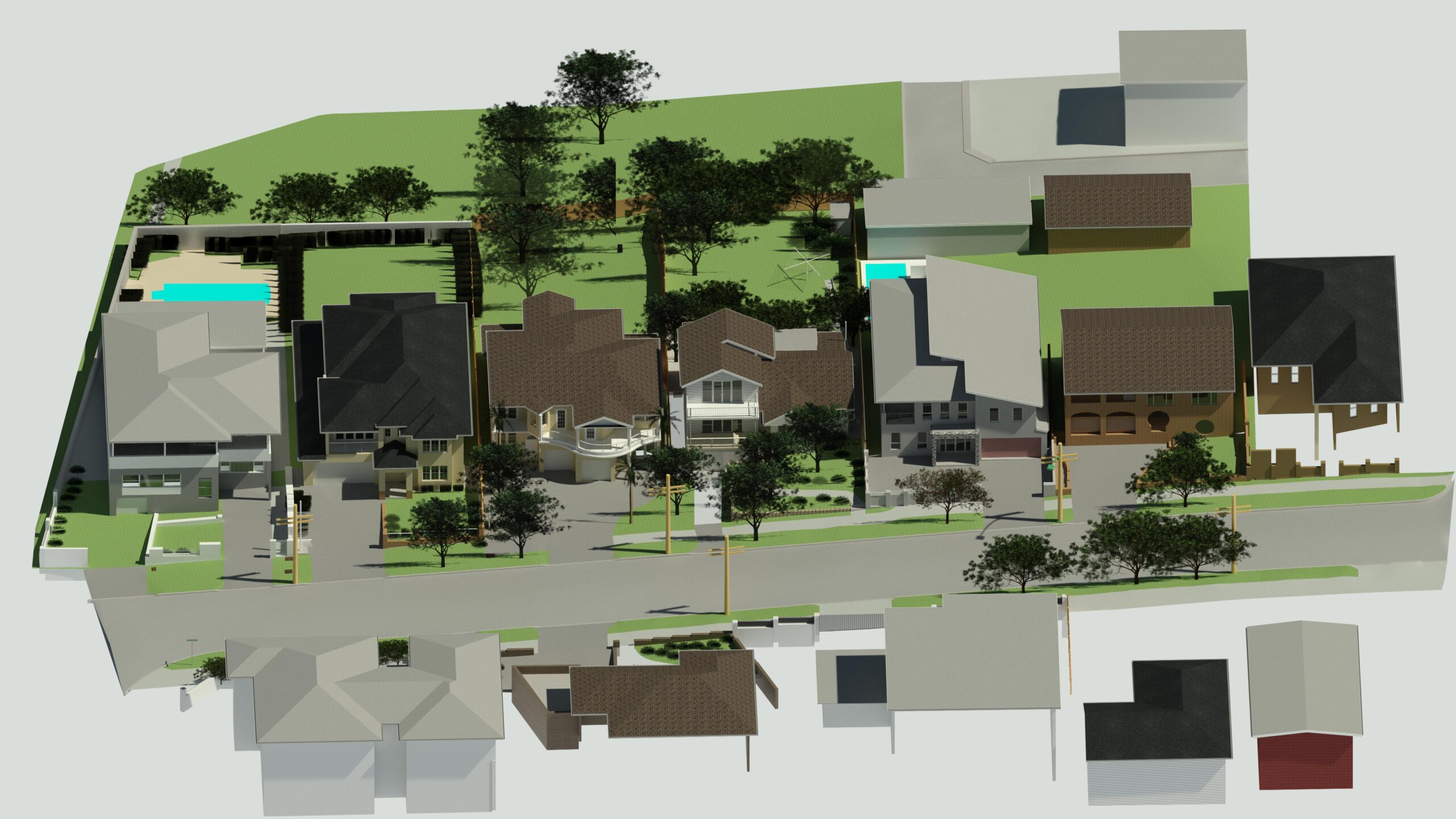
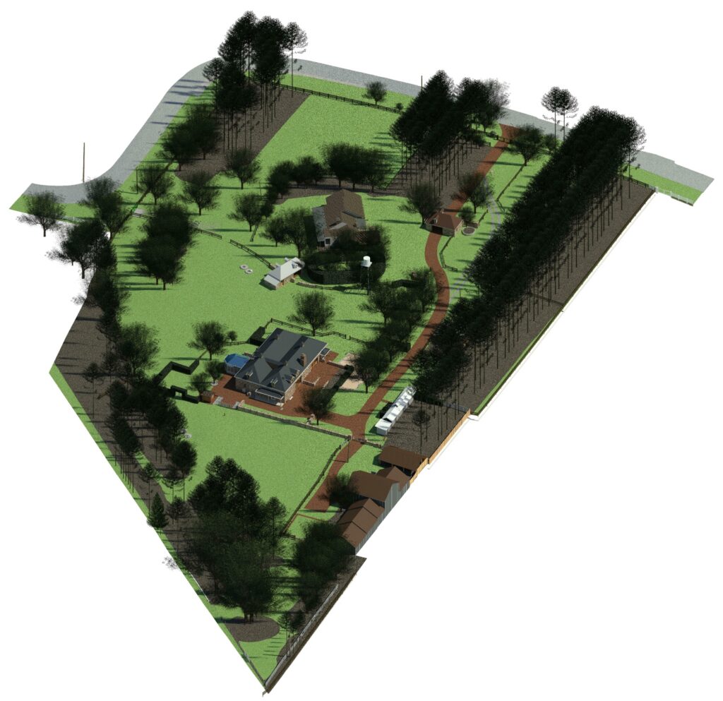
3D Detail Survey Option
We also offer 3D versions of our detail surveys. These high-resolution, immersive models allow clients and designers to visualise the site more intuitively, understand terrain challenges, and speed up the design process. Learn more on our 3D Survey page.
Choosing the Right Surveyor
A detail survey is only as good as the expertise behind it. At C&A Surveyors, we bring:
- Proven experience: Over 100,000 surveys completed across NSW and 200 glowing reviews on Google
- Fast turnaround: Onsite within 48 hours, with plans typically delivered within 3 business days
- Cutting-edge technology: LiDAR scanners, drones, and 3D modelling capability
- Council-compliant outputs: Plans designed to meet local requirements and approval standards
- One-point contact: A dedicated team member guides you from start to finish
![]()
Get Started with C&A Surveyors
Whether you’re an architect needing a survey for design or a homeowner preparing for a DA, we’re here to help. Our experienced team works closely with you to ensure every detail is captured accurately and efficiently.
📞 Call us today or 📩 book a free quote online. Let’s get your project off to a precise start.
Whether you’re designing a new home, adding an extension, or lodging a Development Application (DA), a detail survey is typically required by architects and designers for design purposes, and some councils and certifiers.
Many councils and certifiers however, now require your property’s boundaries to be calculated and defined – contour surveys only place your property boundaries in an approximate location. For this level of detail, you will likely require a Detail & Level Identification Survey. For more information, you can contact our team on (02) 9167 0209 and by clicking the link here.
- What Does a Detail Survey Include?
- Why is a Detail Survey Required?
- Benefits of a Detail Survey
- What’s the Process?
- 3D Detail Survey Option
- Choosing the Right Surveyor
- Get Started with C&A Surveyors
What Does a Detail Survey Include?
Detail surveys capture both horizontal and vertical information about your land. This includes:
- Contours
- Site coordination
- Location of features
- Ridge and gutter heights
- Outline of neighbouring buildings
- Levelling
- Spot levels
This information is compiled into a scaled plan — either 2D or 3D — used by your design professionals and required by council for approval processes.
Why is a Detail Survey Required?
1. Planning and Building Applications
Some local councils in NSW require a detail survey to accompany Development Applications (DA) or Complying Development Certificate (CDC) submissions. It ensures:
- Accurate design in line with site conditions
- Safe, compliant construction
- Neighbouring impact assessments (such as overshadowing and setbacks)
As mentioned earlier, many councils and certifiers now require your property’s boundaries to be calculated and defined – contour surveys only place your property boundaries in an approximate location. For this level of detail, a Detail & Level Identification Survey may be more appropriate.
2. Architectural and Engineering Design
Architects use detail surveys to create site-responsive designs. Without accurate land levels and structure locations, designs may need costly changes later. Engineers also rely on them for stormwater planning, earthworks, and structural design.
3. Property Valuations and Sales
Banks, valuers, and potential buyers may request a detail survey to better understand the land’s characteristics and development potential.
4. Site Analysis and Feasibility Studies
Before investing time and money into design work, a detail survey helps identify potential constraints — such as drainage flows or sloping land.
Benefits of a Detail Survey
- Design with precision: Avoid costly redesigns by planning with accurate information
- Streamline approvals: Council and certifier-ready plans reduce delays in DA or CDC submissions
- Prevent site surprises: Identify challenges early such as sloping land
- Enhance communication: Clear survey plans help architects, builders, engineers, and certifiers stay aligned
What’s the Process?
At C&A Surveyors, we aim to make the process simple and hassle-free:
- Initial Brief – We work with you or your designer to understand your project’s requirements.
- On-Site Survey – Our registered surveyors attend the property to capture all required data.
- Plan Preparation – We draft the information into a professional survey plan tailored to your application or design needs.
- Delivery – Plans are delivered in PDF and CAD formats, ready to hand over to your architect, builder, or council.
You can see how we bring our surveys to life in our video below:
3D Detail Survey Option
We also offer 3D versions of our detail surveys. These high-resolution, immersive models allow clients and designers to visualise the site more intuitively, understand terrain challenges, and speed up the design process. Learn more on our 3D Survey page.
Choosing the Right Surveyor
A detail survey is only as good as the expertise behind it. At C&A Surveyors, we bring:
- Proven experience: Over 100,000 surveys completed across NSW and 200 glowing reviews on Google
- Fast turnaround: Onsite within 48 hours, with plans typically delivered within 3 business days
- Cutting-edge technology: LiDAR scanners, drones, and 3D modelling capability
- Council-compliant outputs: Plans designed to meet local requirements and approval standards
- One-point contact: A dedicated team member guides you from start to finish
![]()
Get Started with C&A Surveyors
Whether you’re an architect needing a survey for design or a homeowner preparing for a DA, we’re here to help. Our experienced team works closely with you to ensure every detail is captured accurately and efficiently.
📞 Call us today or 📩 book a free quote online. Let’s get your project off to a precise start.